The Road Safety Foundation organisation, working with the Department for Transport, has identified a section of the A586 in Blackpool as having lower road safety characteristics than the national average. Following this, Blackpool Council has received funding from the Government’s Road Safety Partnership scheme to implement safety improvements to benefit both road users and pedestrians using this area.
Find out more about the Safer Roads Fund
The planned proposals for the full scheme of works extend from outside Blackpool North station all the way up to the Westcliffe Drive/Mansfield Road junction.
The proposed measures are intended to reduce road traffic collisions, enhance pedestrian and cyclist safety and improve the overall traffic flow in the area.
The full list of proposals and plans for each area can be viewed below.
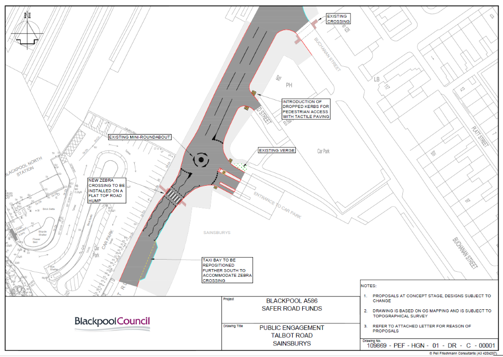
- New taxi bay on Talbot Road opposite Blackpool North Station – to accommodate a new zebra crossing.
- Installation of zebra crossing on Talbot Road opposite Blackpool North Station – to allow pedestrian access from the station to the Sainsbury’s store and other services.
- Installation of an uncontrolled crossing with tactile paving at Talbot Road/Seed Street junction – to increase the safety and accessibility for pedestrians.
 Map showing Safer Roads highway improvement proposals for area 1 (Talbot Road)
×
![]()
- Introduction of cycle lanes on Talbot Road – to provide a safe and accessible route for people to cycle in/out of Blackpool town centre.
- Widening of the footpath on Talbot Road/Whiteside Street – to give pedestrians more space and increase vehicle separation, promoting safety and inclusion.
- Installation of an uncontrolled crossing with tactile paving at Talbot Road/Whiteside Street junction – to increase the safety and accessibility for pedestrians.
- Junction narrowing at Talbot Road/Whiteside Street – creating shorter crossing distance for pedestrians. The tighter corner will also require vehicles to slow down when turning.
- Traffic island width reduced (remains to guidance) by Talbot Road/Sainsbury’s petrol station entrance – to enable introduction of cycle lane.
- Junction narrowing at Talbot Road/Sainsbury’s petrol station entrance – creating shorter crossing distance for pedestrians. The tighter corner will also require vehicles to slow down when turning.
 Map of Safer Roads highway improvement proposals for area 2 (Talbot Road)
×
![]()
- Introduction of cycle lanes on Talbot Road, up to Gorton Street – to provide a safe and accessible route for people to cycle in/out of Blackpool town centre.
- Installation of uncontrolled crossing with tactile paving on the following side roads; Edelston Road, Gorton Street, Thomas Street and Hardman Street – to increase safety and accessibility for pedestrians.
- Bus stop to be relocated from Talbot Road/Hardman Street to Talbot Road/Edelston Road.
- Installation of tactile paving on existing uncontrolled crossing point with refuge island on Talbot Road, near Gorton Street – to increase safety and accessibility for pedestrians.
- Widening of the footpath on Talbot Road/Thomas Street – to give pedestrians more space and increase vehicle separation, promoting safety and inclusion.
- Junction narrowing at Talbot Road/Thomas Street – creating shorter crossing distance for pedestrians. The tighter corner will also require vehicles to slow down when turning.
- Installation of tactile paving across the Talbot Road/Thomas Street and Talbot Road/Victory Road junctions – tactile paving enhances pedestrian safety, especially for those visually impaired.
- Introduction of a 20mph speed limit and traffic island on Talbot Road, by Victory Road junction – reducing vehicle speeds increases pedestrian and cyclists’ safety and smooths traffic flow creating more road capacity. The traffic island provides pedestrian refuge to increase safety and ease of use.
 Map of Safer Roads highway improvement proposals for area 3 (Talbot Road)
×
![]()
- Bus stop to be relocated from Talbot Road/Hardman Street to Talbot Road/Edelston Road.
- Installation of uncontrolled crossing with tactile paving on the following side roads; Hardman Street and Greenhill Place – to increase safety and accessibility for pedestrians.
- Installation of footpath and kerbs on Talbot Road/Cecil Street junction – to increase safety for pedestrians.
- Footpath narrowing on Talbot Road between Hardman Street and Henthorne Street – to accommodate highway improvements.
- Introduction of parking lay-by on Talbot Road between Greenhill Place and Henthorne Street – formalising parking areas means other vehicles can travel easily without having to avoid parked cars.
- Installation of tactile paving across the Talbot Road/Henthorne Street and Talbot Road/Coleridge Road junctions – tactile paving enhances pedestrian safety, especially for those visually impaired.
- Installation of tactile paving on existing uncontrolled crossing point with refuge island on Talbot Road between Henthorne Street and Coleridge Road – to upgrade existing uncontrolled crossing point and refuge island.
 Map of Safer Roads highway improvement proposals for area 4 (Talbot Road)
×
![]()
- Installation of uncontrolled crossing with tactile paving on the following side roads; Foxdale Avenue and Mather Street – to increase the safety and accessibility for pedestrians.
- Upgrades to the existing zebra crossing across Talbot Road, adjacent to Foxdale Avenue, Mather Street – to increase user safety and comply with current guidance.
 Map of Safer Roads highway improvement proposals for area 5 (Talbot Road)
×
![]()
- Extension of the existing Talbot Road/Layton Square bus lay-by – this will allow more room for multiple buses to stop at once, increasing the stop’s functionality as 9 different bus services use this route.
- Upgrades to the existing zebra crossings across Talbot Road/Westcliffe Drive and Layton Road/Westcliffe Drive – to increase user safety and comply with current guidance.
- Footpath narrowing on Layton Road, opposite Broughton Avenue – to accommodate upgraded zebra crossing.
- Installation of uncontrolled crossing with tactile paving on the following side roads; Broughton Avenue, Grange Road, Annesley Avenue and Grenfall Avenue – to increase the safety and accessibility for pedestrians.
- Widening of the footpath on Westcliffe Drive between Grange Road and Grenfall Avenue – to give pedestrians more space and increase vehicle separation promoting safety and inclusion.
- Installation of a new zebra crossing on a raised table with guardrail and verge on Westcliffe Drive, between Grange Road and Grenfall Avenue – to increase user safety and comply with current guidance.
 Map of Safer Roads highway improvement proposals for area 6 (Westcliffe Drive)
×
![]()
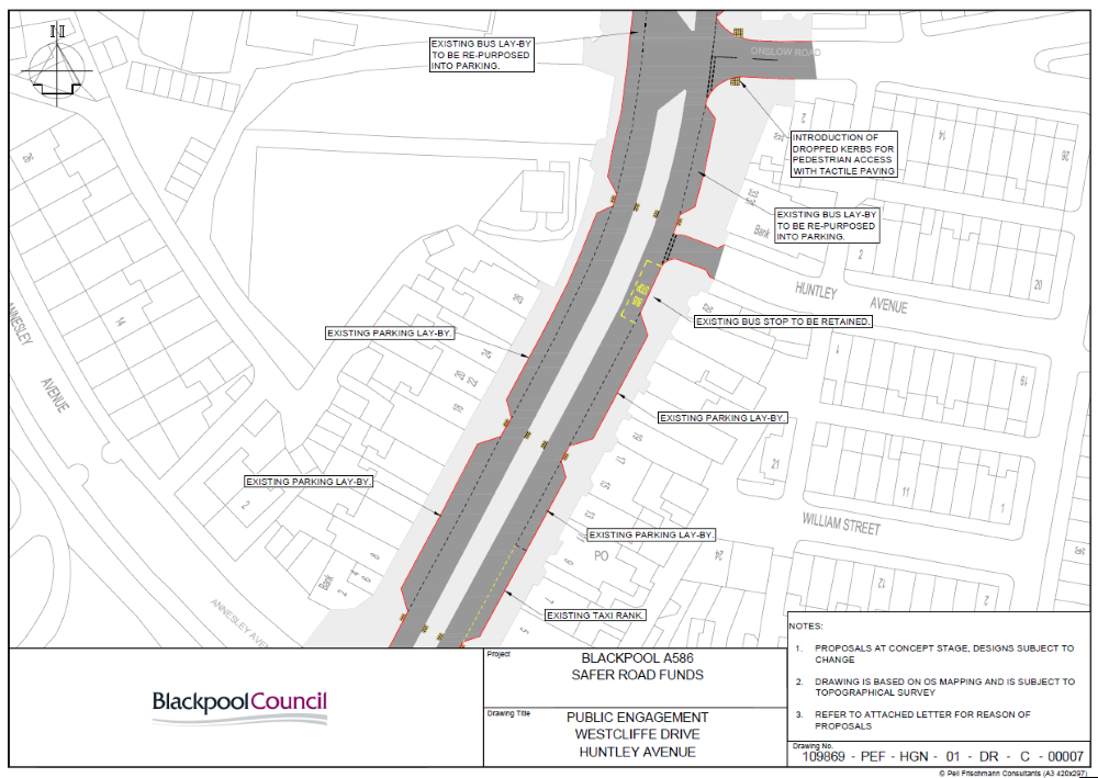
- Bus stop lay-by on Westcliffe Drive/Huntley Avenue to be repurposed into parking – to accommodate for more parking in the existing lay-by. The existing bus stop outside “Fisher’s Plaice” will remain.
- Installation of an uncontrolled crossing with tactile paving at Westcliffe Drive/Onslow Road junction – to increase the safety and accessibility for pedestrians.
- Bus stop lay-by on Westcliffe Drive/Granby Drive to be repurposed into parking – to accommodate for more parking in the existing lay-by. The existing bus stop outside the “Layton Institute” will remain.
- Please note, the parking lay-bys and taxi rank on Westcliffe Road between Grenfall Avenue and Huntley Avenue will remain.
 Map of Safer Roads highway improvement proposals for area 7 (Westcliffe Drive)
×
![]()
- Relocation of the Westcliffe Drive/Granby Avenue bus stop – to accommodate for more parking in the existing lay-by.
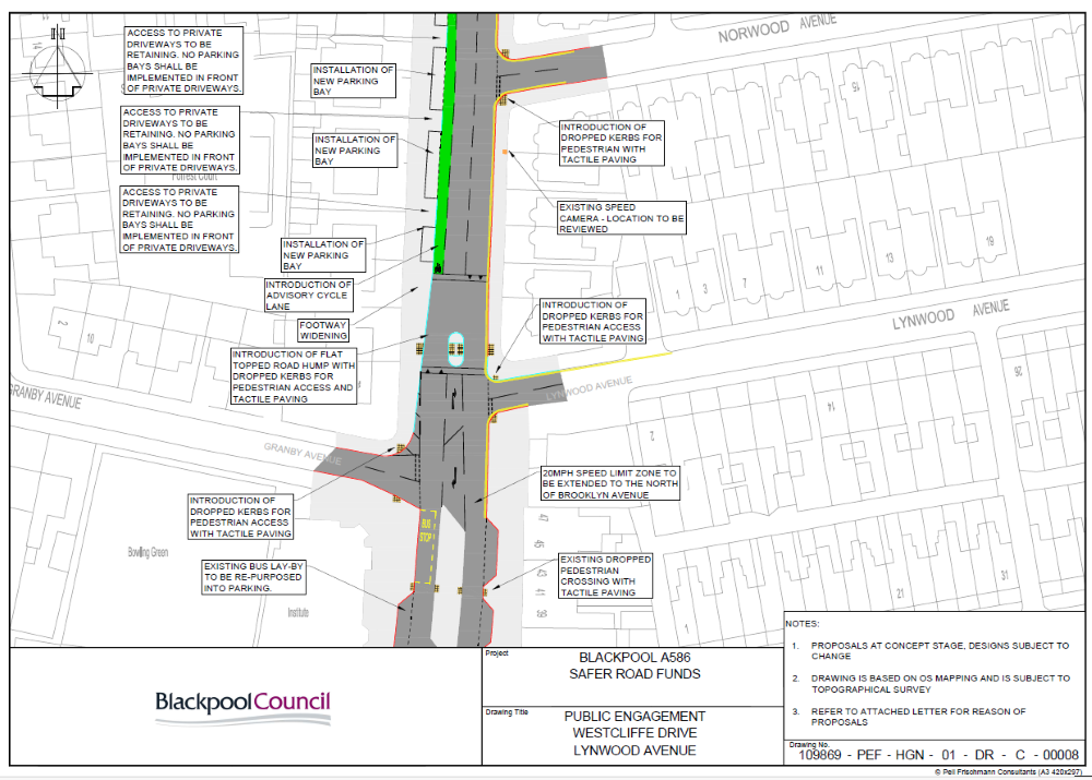
- Extension of the existing 20mph speed limit on Westcliffe Drive up to Brooklyn Avenue – to reduce vehicle speeds and increase pedestrian and cyclists’ safety.
- Installation of uncontrolled crossing with tactile paving on the following side roads; Granby Avenue, Lynwood Avenue and Norwood Avenue – to increase the safety and accessibility for pedestrians.
- Introduction of a raised table with an uncontrolled crossing and tactile paving across Westcliffe Drive, north of Lynwood Avenue – a raised table crossing makes pedestrians more visible to vehicles and reduces their speed, increasing pedestrian safety.
- Introduction of cycle lane on Westcliffe Drive, north of Lynwood Avenue – to provide a safe and accessible way for people to cycle in/out of Blackpool town centre.
- Introduction of a parking lay-bys on Westcliffe Drive between Granby Avenue and Pelham Avenue – formalising parking areas means other vehicles can travel easily without having to avoid parked cars.
 Map of Safer Roads highway improvement proposals for area 8 (Westcliffe Drive)
×
![]()
- Introduction of parking lay-bys on Westcliffe Drive, between Granby Avenue and north of St Mark’s Place – formalising parking areas means other vehicles can travel easily without having to avoid parked cars.
- Installation of uncontrolled crossing with tactile paving on the following side roads; Pelham Avenue, Highbury Avenue, St Mark’s Place and Brooklyn Avenue – to increase the safety and accessibility for pedestrians.
- Introduction of cycle lane on Westcliffe Drive – to provide a safe and accessible way for people to cycle in/out of Blackpool town centre.
- Extension of the existing 20mph speed limit on Westcliffe Drive up to Brooklyn Avenue – to reduce vehicle speeds and increase pedestrian and cyclists’ safety.
- Introduction of a designated parking bay for official church use only, outside St Mark’s Church – to help alleviate disruption and congestion that could be caused when a funeral service is taking place.
 Map of Safer Roads highway improvement proposals for area 9 (Westcliffe Drive)
×
![]()
- Introduction of a designated parking bay for official church use only, outside St Mark’s Church – to help alleviate disruption and congestion that could be caused when a funeral service is taking place.
- Extension of the existing 20mph speed limit on Westcliffe Drive up to Brooklyn Avenue – to reduce vehicle speeds and increase pedestrian and cyclists’ safety.
- Introduction of cycle lane on Westcliffe Drive up to Mansfield Avenue – to provide a safe and accessible way for people to cycle in/out of Blackpool town centre.
- Installation of a new uncontrolled crossing point with a refuge island across Westcliffe Drive, north of Brooklyn Avenue – the traffic island provides pedestrian refuge, increasing safety and ease of use.
- Installation of an uncontrolled crossing with tactile paving at Westcliffe Drive/Mansfield Road junction – to increase the safety and accessibility for pedestrians.
- Widening of the footpath on Westcliffe Drive/Mansfield Road – this gives pedestrians more space and increases vehicle separation, promoting safety and inclusion.
- Junction narrowing at Westcliffe Drive/Mansfield Road – creating shorter crossing distance for pedestrians. The tighter corner will also require vehicles to slow down when turning.
- Relocation of the bus stop on Westcliffe Drive, outside Tesco Express – will be relocated slightly further north where Westcliffe Road is wider and vehicles can pass more easily.
- Narrowing of the footpath on Westcliffe Drive, outside Tesco Express – to accommodate relocated bus stop.
 Map of Safer Roads highway improvement proposals for area 10 (Westcliffe Drive)
×
![]()
Contact us
Residents and businesses in the affected areas have been sent a letter with a plan of the proposed changes and a form to provide their feedback.
If members of the public would like to provide feedback or have any questions, please contact us by emailing traffic.management@blackpool.gov.uk.
All feedback should be submitted by Monday 8 September 2025.